There's very little scientific debate about the existence of surface water on Mars in its past. The evidence at this point is overwhelming. Orbiter images clearly show river channels and deltas, and rovers have found ample minerals that only form in the presence of water. Now the scientific debate has moved on. Scientists are trying to learn the extent of Martian surface water, both on the planet's surface and through time.
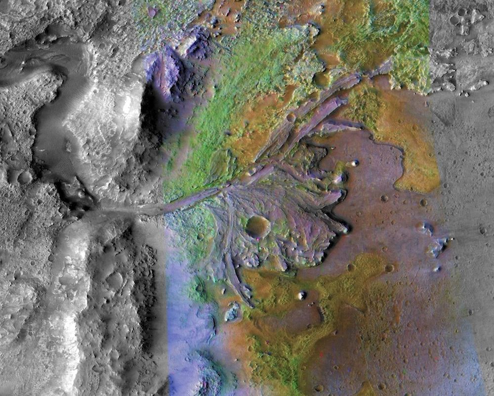
NASA's Mars Reconnaissance Orbiter (MRO) is a prolific purveyor of images of Mars' surface. One of its most well-known image shows Jezero Crater, the landing site of the Mars Perseverance rover. Jezero Crater is an ancient paleolake filled by an ancient river that created a delta of sediments. The orbiter also identified clays and carbonate salts, minerals that were altered by water in the planet's past.
There are two schools of thought around Mars' watery past. One says that water was stable on the Martian surface for long periods of time, while the other states that the water channels were carved during geologically brief periods of time when climate shifts caused ice sheets to melt. Call the first one the 'warm and wet' theory and the second one the 'cold and dry' theory. Both theories are well developed, and make predictions about what scientists will find when they dig deeper.
Some research into Noachis Terra supports the idea that water features there were carved by ice-related processes during short-lived periods of wetness, the cold and dry theory. This 2016 paper illustrates that point of view. "Our studied valleys' association with ice-rich material and abundant evidence for erosion caused by downslope flow of ice-rich material are consistent with a cold, wet Mars hypothesis where accumulation, flow, and melting of ice have been dominant factors in eroding crater valleys," those researchers concluded.
Not all regions of Mars have been studied equally, and the Noachis Terra is not as well-studied as some other regions. The 'warm and wet' climate theory predicts that Noachis Terra would've had high levels of precipitation. However, there's an overall lack of Valley Networks (VNs) in the region. Valley Networks are similar to Earth's river drainage basins and are compelling evidence of Mars' watery past.
New research presented at the Royal Astronomical Society's National Astronomy Meeting presented a different sort of evidence to support the high levels of precipitation predicted in Noachis Terra by the warm and wet theory. It's titled "The Fluvial History of Noachis Terra, Mars," and the lead researcher is Adam Losekoot. Losekoot is a PhD student at the Open University, a public research university in the UK.
"Studying Mars, particularly an underexplored region like Noachis Terra, is really exciting because it's an environment which has been largely unchanged for billions of years. It's a time capsule that records fundamental geological processes in a way that just isn't possible here on Earth," Losekoot said in a press release.
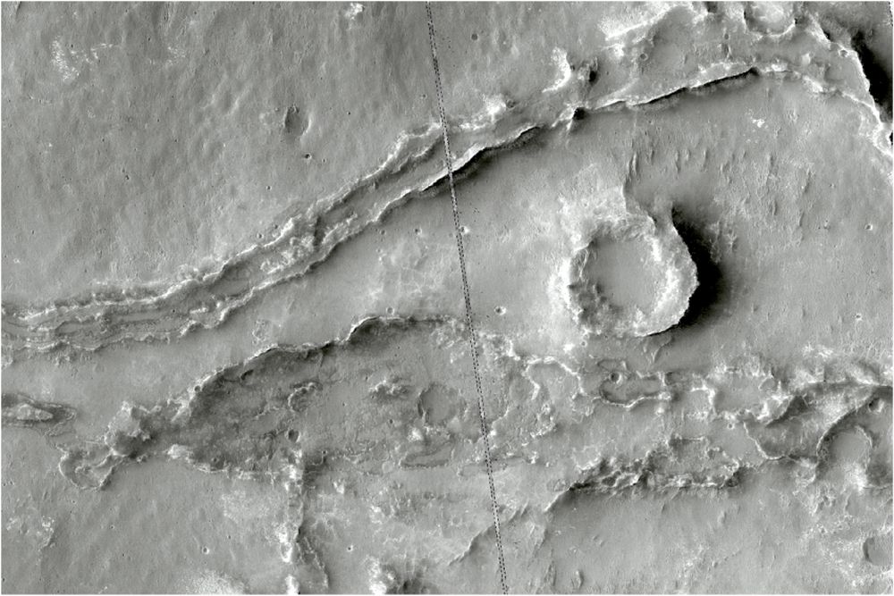
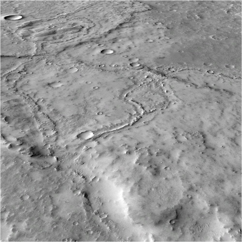
The evidence Losekoot and his fellow researchers uncovered is in the form of Fluvial Sinuous Ridges.
"Noachis Terra, in Mars’ southern highlands, is a region where ‘warm, wet’ climate models predict high rates of precipitation, but is poorly incised by VNs," Losekoot explained. "We searched instead for Fluvial Sinuous Ridges (FSRs, aka inverted channels) here as they provide alternate evidence to VNs for stable surface water."
FSRs are winding, elevated features left behind from Mars' watery past. They form when water flows across the surface carrying sediment with it. The sediment deposits become harder than the rock in the surrounding terrain due to compaction and mineral precipitation. When Mars' water disappeared, aeolian erosion ate away at the softer, surrounding rock, leaving the elevated FSRs behind.
To find the FSRs in Noachis Terra, Losekoot and his co-researchers turned to NASA's MRO. No other mission has done more to reveal Mars' past than the MRO. They used data from its HiRISE and other instruments, as well as data from the Mars Orbital Laser Altimeter on the Mars Global Surveyor, to identify FSRs.
Losekoot and his co-researchers found 15,000 km of FSRs in Noachis Terra. "We find FSRs to be common across Noachis Terra, with a cumulative length of more than 15,000 km. These are often isolated segments, but some systems are hundreds of km in length," Losekoot writes.
The FSRs are broadly distributed across Noachis Terra, and some are tens of meters tall. That means the water flowed for a long time.
"The broad distribution of FSRs suggests a broadly distributed source of water," Losekoot writes. "The most likely candidate is precipitation, suggesting a benign surface environment. For FSRs to have formed mature, interconnected systems, up to tens of meters high, these conditions must also have been relatively long-lived."
"This suggests that ~3.7 Ga, Noachis Terra experienced warm and wet conditions for a geologically relevant period," Losekoot explained.
The way the FSRs are distributed across Noachis Terra and their extent suggests that precipitation is responsible. They also form large, interconnected systems, which suggests the watery period was long-lived. This work supports the idea that Mars was warm and wet for a long time, rather than just for bursts of time when ice sheets melted.
"Our work is a new piece of evidence that suggests that Mars was once a much more complex and active planet than it is now, which is such an exciting thing to be involved in," said Losekoot.